The Junction of Flood and Community
Pacific Junction
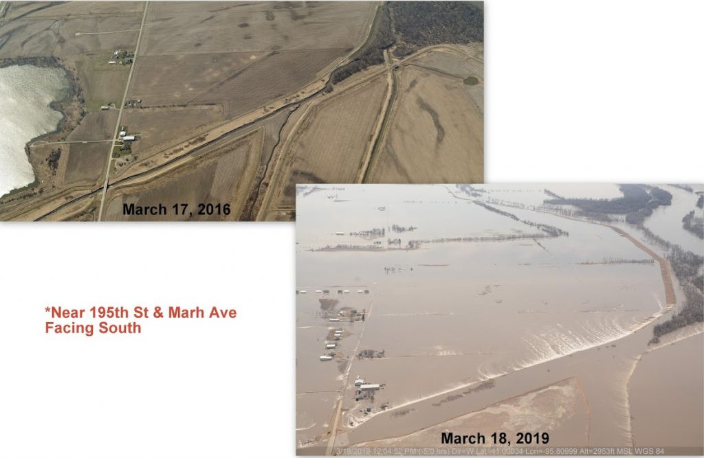
A video from the Mills County Emergency Management website filmed on March 16, 2019 shows the waters of the Missouri River oozing over miles levees. In most places, the water slides down the interior wall of the levee. In some places, the force of the water or weakness of the wall has produced instead a waterfall on the interior of the levee. Another video from the next day, March 17, shows railroad tracks running along raised earth with water on either side. In some places, only a single track remains; the water has taken the other one. In other places, water rushes through a wide breach in the earthwork on which the tracks run. Yet another video, this one from March 31, features a train snaking slowly along tracks flanked on both sides by flood water spread out across the plain, immersing homes and outbuildings, commercial structures and inventory, farms and fields.
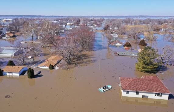
The last video focuses on the town of Pacific Junction. Once the town could count on the tracks to mark the extent of a flood reaching out from the Missouri toward them. But that was not true in 2019 as the massive amount of water in the river crashed through dams further north and topped levees all along its course to the Mississippi River.
March was the first of three floods on the Missouri in 2019. There was another in May and a third in September (ongoing as PWM writes this story).
If you’ve lived by a river, especially one monitored by gages, you know the stories numbers can tell. On September 15, Andrea Sahouri wrote in The Des Moines Register that the US Army Corps of Engineers was reducing the amount of water they released from the Gavins Point Dam on the Nebraska-South Dakota border where both of those states touch northwest Iowa. The amounts would be reduced for three days to 65,000 cubic feet per second (cfs) and then to 60,000cfs to accommodate the expected heavy rains further south in the Missouri River basin. After that, the Corps warned, they would be raising the cfs by 5,000 every day until it reached 80,000. Those in areas who were still wrestling with flood damage from March and May, Sahouri wrote, were advised by the Corps to be especially cautious.
Four days later Shelby Fleig was writing in the same newspaper that a flood prevention berm on the Missouri had been breached on September 18, that there had been three inches of rain in the river basin, and that the river was rising a half foot to over 30 feet. Not so many years ago a depth of 22.5 feet was considered extraordinary. More rain was expected in southwest Iowa as well as north in South Dakota. Water was surrounding Interstate 29 near the breach in Pottawattamie County just north of Mills County. That highway runs north-south along the Missouri on the Iowa side.
Two days later, September 21, the Facebook page of Fremont County Emergency Management (Fremont County being just south of Mills County) reported that 79,900 cfs was coming out of the Gavins Point Dam and 142,000cfs was passing through the Missouri River gage at Nebraska City, just across the river from southwest Iowa. 142,000.
That same Facebook page reminded all viewers that they could give and southwest Iowa viewers that they could receive funds from omahafoundation.org that had so far collected $500,000 to help residents of Harrison, Mills, and Fremont Counties rebuild.
Sources: on-line: Mills County Emergency Management, millscoia.us; Fremont County Emergency Management, co.fremont.ia.us; Andrea Ma Sahouri, “After heavy rains upstream…,” The Des Moines Register, September 15, 2019; Shelby Fleig, The Des Moines Register, September 19, 2019. Thanks especially to Larry Hurst, Director of Mills County Emergency Management, for permission to use their photographs and reference their videos on the PWM site.