Flood
Flood
Water is an essential natural resource, but in excess it can lead to flood disasters. A flood is an overflowing of a large amount of water over what is normally dry land. Rivers flood when streamflow overtops the river banks. When the amount of flow causes widespread damage and threats to human health, a flood disaster is born. Among the types of natural disasters, floods are the costliest and affect the most people worldwide. The pervasive impact of floods stems from the fact that they can occur in so many places, including major rivers, small creeks, coastal and lake shores, low lying urban areas, mountain streams, and deserts.
What Influences River Floods?
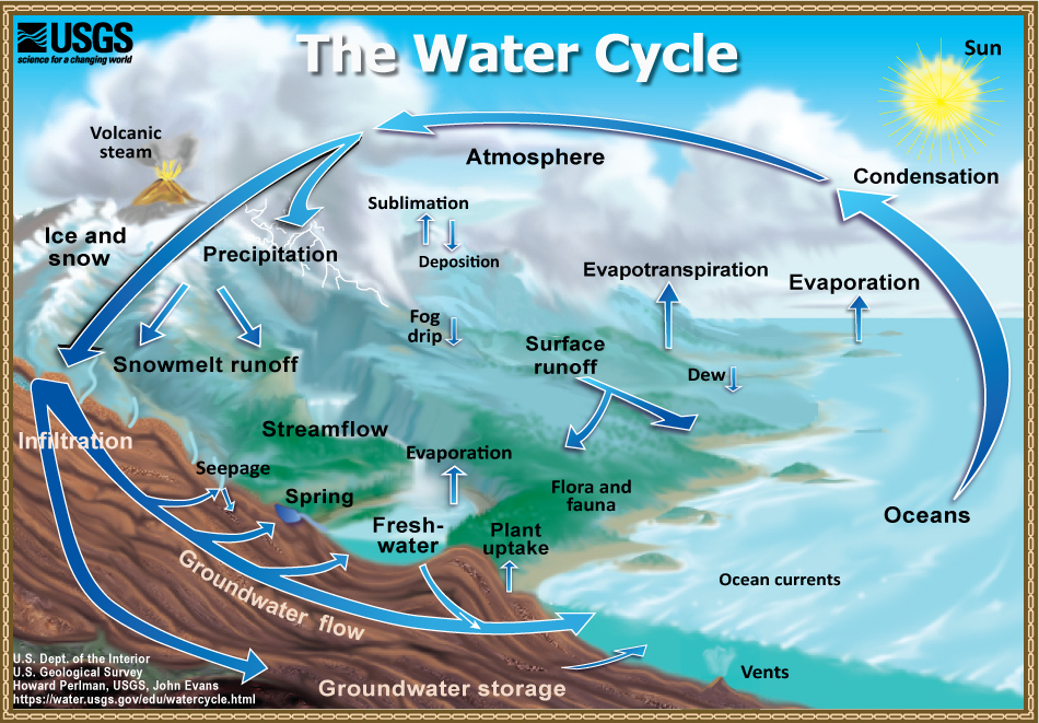
Natural characteristics such as rainfall, soil texture, land slope, and vegetation play a central role in the formation of river floods. As precipitation falls to the ground as rain or snow, some of it infiltrates underground, while some evaporates from the land surface and vegetation. The remainder moves across the land surface into streams and lakes according to gravity. This water is called runoff and is the main source of floods. Runoff is a major part of the water cycle, and excess runoff can lead to high levels of flooding.
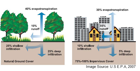
Human process also play a large role in how floods form. Floodplains provide many benefits to people, including proximity to water for drinking, transportation, and industry, nutrient rich soils for agriculture, flat land that eases construction, and aesthetic views. In their natural form, floodplains improve soil and water quality, provide water supply, and provide recreational settings and wildlife habitats. However, human conversion of floodplains generally increases their potential for extreme floods. Agriculture and forestry erodes soil that adds sediment to rivers and raises flood heights. Urbanization transforms land that naturally slows and absorbs runoff into impermeable surface such as roads, parking lots and building roofs. As a result, less rainfall infiltrates into the ground and evaporates into the air in urban areas, while more becomes flood water.
What Makes Floods Dangerous?
Floods generally take on four major forms: (1) regional river floods from high rainfall runoff and snowmelt, (2) localized and short duration flash floods that quickly develop in small creeks, (3) coastal floods from storm surge and sea level rise, and (4) pluvial floods from intense rainfall that overwhelms urban stormwater infrastructure. With many cities and towns located on along rivers and coastlines, extreme floods in these places can become major disasters that inflict damage to property, infrastructure, and agriculture. These impacts often lead to displacement of people from their homes, loss of income and employment, and reduced tax revenue for communities.

Even after a flood recedes, impacted areas can still pose risks to human health. Floods can leave behind contamination from sewage, chemicals, and mold. Residents may be left without electricity or clean drinking water, which in some cases can lead to disease outbreak.
Managing Floods
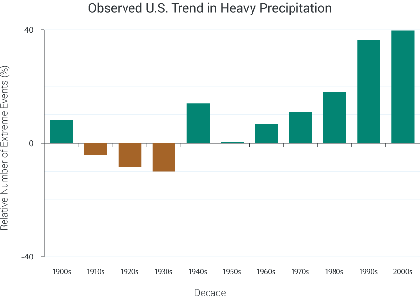
FEMA runs the National Flood Insurance Program, which aims to reduce flood impacts by providing affordable insurance to property owners, and incentivizing communities to practice sound floodplain management. Through the National Flood Insurance Act, the federal government provides subsidized flood insurance to property owners in communities that map flood prone areas and enact ordinances to regulate their development. Sustained flood insurance coverage is mandatory for homeowners with federally-backed mortgages. Computer modeling allows engineers to predict the location and likelihood of flooding. Digital floodplain maps for the nation are available online from the FEMA Map Service Center. If you community participates in the National Flood Insurance Program, you can type your address to the search bar, and determine your exposure to floods. Floods and Climate Change Overall, climate change is expected to increase flood risk, although with variations from place to place. Evaporation rates increase in a warmer climate, and the atmosphere can hold a larger amount of water vapor. This will increase the average annual precipitation in some places, and decrease it in others. However, the most significant impact on floods is likely to be increasing variability of extreme rain events. A greater share of each year’s rainfall is expected to occur in heavy downpours, a trend that has already been observed across recent decades.
Did You Know?
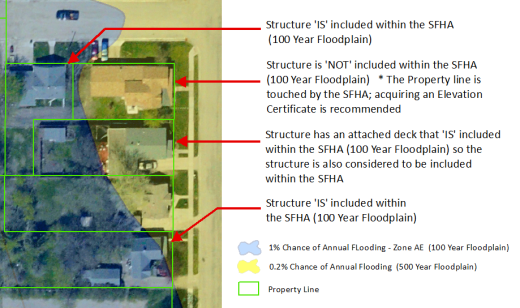
The 100-year flood is not a flood that occurs every 100 years. Although the terms 100-year flood and 500-year flood are commonly used, they are often misunderstood. The 100-year flood is an event that has a 1% chance of occurring in any given year, while the 100-year floodplain is the area of land that flood would inundate. One way to understand the likelihood of a 100-year flood is to imagine a bag containing 1 blue marble and 99 green marbles. Every year, you draw one marble, note its color, and then replace it in the bag. If you draw the blue marble, that is the 100-year flood. But because you return the blue marble back into the bag, it’s possible to draw it again the next year. In the same way, a 100-year flood could occur two years in a row. Due to confusion about the meaning of the 100-yr floodplain, FEMA abandoned use of this term, and they now refer to the regulatory 100-year floodplain as the Special Flood Hazard Area. Homes within the Special Flood Hazard Area have roughly a 1 in 4 chance of being flooded over the course of a 30-year mortgage.